Tartu, Estonia’s second-largest city, today consists of 18 districts and one rural area, which took their current form after the 2017 administrative reform. Each district has its own distinctive character, history and feel, which makes Tartu a varied and interesting city.
The districts range from a compact city centre to spacious residential areas and various development zones, offering residents a variety of approaches to the living environment. The largest district is Annelinn with 24,551 residents, while the smallest, Maarjamõisa, focuses mainly on the university and medical campus.
The diversity of Tartu’s districts is reflected in both their architectural appearance and their historical and cultural significance. Bohemian Karlova, modern Annelinn and the history-rich city centre show how the city has developed through the centuries and adapted to the needs of different eras.
General division of Tartu’s districts
Tartu consists of 18 districts and one rural area. The biggest change took place in 2017, when Tähtvere rural municipality joined the city as part of the administrative reform.
Administrative boundaries and number of districts
Tartu has a total of 18 districts and one rural area. Each district has clearly defined boundaries shown on the city’s official maps.
The districts differ significantly in size and population. Annelinn is the largest district by population with 24,551 residents as of 2020.
The smallest district is Maarjamõisa, where a large university and medical campus is located. There are many jobs but few homes here.
All of today’s Tartu districts lie on one or the other side of the Emajõgi river. No district extends across the river to both banks.
The merger of Tähtvere municipality with the city of Tartu
- In one year an administrative reform took place in Estonia that significantly changed Tartu’s boundaries. Tähtvere rural municipality joined the city of Tartu at that time.
The former Tähtvere rural municipality now forms Tartu’s rural area. It is the only rural area that is part of the city of Tartu.
The merger significantly increased Tartu’s territory. The city also gained new residents and infrastructure objects.
The reform turned Tartu into one of the larger local-government units in Estonia. The city gained more opportunities for developing and planning the area.
A characterisation of the Tartu urban area
Tartu’s districts are very different both in architecture and in function. The city centre is the heart of the city, where the main cultural and administrative institutions are located.
Annelinn is mainly a housing estate with large apartment buildings. Soviet-era architecture with five- and nine-storey buildings dominates here.
Karlova is a compact district with late-19th and early-20th-century architecture. It has become popular among young families and intellectuals.
Some districts such as Jaamamõisa and Ihaste retain a more rural feel. They have their own historical roots and distinctive features that set them apart from the city centre.
The most important and best-known districts in Tartu
Tartu’s most important districts are the city centre as the heart of the city, popular residential areas like Karlova and Supilinn, and the largest district, Annelinn, together with Ülejõe. These areas form the main residential and cultural core of the city.
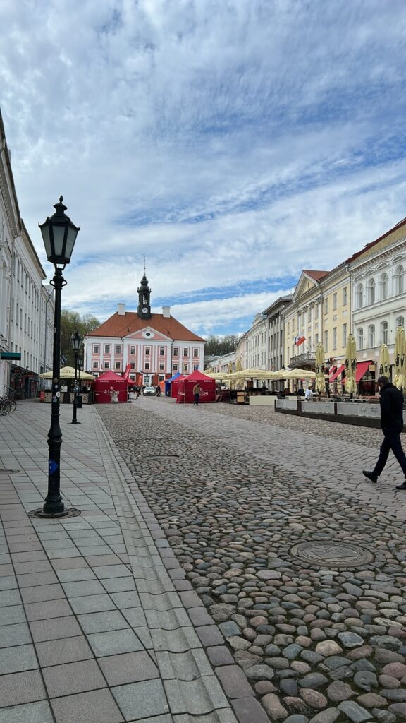
City centre and Old Town
The city centre is the heart of Tartu and its historical centre. There are 6,465 residents on 180 hectares here.
The Old Town covers the medieval area enclosed by the city wall. The ancient Estonian stronghold was also located here.
Important sites in the city centre:
- Toomemägi and the Observatory
- The Town Hall and Town Hall Square
- The University of Tartu
- The Botanical Garden and AHHAA Centre
Cultural life is an important part of the city centre. The Vanemuine Theatre and Uus Teater are based here. The Artists’ House and Writers’ House are also located in the city centre.
Education and research institutions dominate the area. The Supreme Court, the Ministry of Education, and the Genome Centre are situated here.
Karlova and Supilinn
Karlova is a compact district with 8,444 residents, built at the end of the 19th century on the lands of Karlova manor. Architect Fromhold Kangro designed many of the local buildings.
The district’s boundaries stretch from Võru street to the Emajõgi river. Tähe street is the main thoroughfare.
Characteristic street names:
- Õnne street
- Vaba street
- Sõbra street
Karlova has become a prestigious area. Young families and intellectuals have moved in alongside long-time residents. The popular Karlova bar, or Barlova, is the heart of the district’s nightlife.
Supilinn lies near Karlova. It is known as a residential area of small wooden houses that retains a historical atmosphere.
Annelinn and Ülejõe
Annelinn is Tartu’s largest district with 24,551 residents. It covers 540 hectares. It is a typical Soviet-era housing estate.
Its history goes back to Anne manor, of which a small park has been preserved. Anne canal is also part of Annelinn.
Building periods:
- 1969 – the first phase of planning
- Mart Port and Malle Meelak drew up the master plan
- Five- and nine-storey buildings dominate
Ülejõe lies on the other bank of the Emajõgi. The area is smaller and has more single-family housing compared to Annelinn’s apartment blocks.
Anne street forms a historical axis. It starts in Ülejõe between tsarist-era buildings and reaches the former Anne manor.
Residential areas and varied housing
Tartu’s residential areas are divided into different settlement types, ranging from Soviet-period apartment blocks to modern detached-house areas. Each area has its own architectural features and resident profile.
Tammelinn and Tähtvere
Tammelinn is one of Tartu’s older planned residential areas. It was built in the 1970s–1980s with Soviet-period apartment buildings.
The area mainly consists of five- to nine-storey residential buildings. Tammelinn’s architecture reflects typical Soviet-era urban planning.
Tähtvere joined the city of Tartu in 2017 during the administrative reform. It was previously a separate rural municipality.
Tähtvere differs from Tartu’s other districts in its rural character. Detached houses and lower buildings dominate the area.
The area gives residents more space and a more nature-rich environment. Tähtvere still preserves much of its rural feel.
Vaksali and Veeriku
Vaksali district lies near the railway station. The area takes its name from the historical railway connection.
The district has both apartment blocks and detached houses. The architecture is mixed, with buildings from different periods.
Vaksali is an important transport hub. The railway station connects Tartu with other Estonian cities.
Veeriku is a smaller residential area. Mainly detached houses and smaller apartment buildings are located here.
The area is calm and family-oriented. Veeriku’s streets are usually quieter than those in the city centre.
Residents value the area’s homely atmosphere. Veeriku offers an alternative to larger apartment-block districts.
Variku and Ränilinn
Variku is one of the smallest districts in Tartu. The area lies on the city’s outskirts.
The housing stock consists mainly of detached houses. Variku retains a more rural character.
Ränilinn is also a smaller residential area. It is located near the Emajõgi river.
Detached houses and smaller apartment buildings dominate the district. The architecture is varied.
Ränilinn’s residents can enjoy the proximity of the river. The area offers a peaceful living environment.
Both districts suit families who prefer the atmosphere of a smaller community. These areas offer an alternative to larger apartment-block districts.
Industrial and development areas
Tartu’s industrial and development areas bring together various business, logistics and manufacturing companies. These areas have taken shape according to function rather than along historical or natural boundaries.
Ropka and the Ropka industrial district
The Ropka industrial district is on the city’s southern boundary, between the Emajõgi river and the Petseri railway. The area covers 364 hectares and is home to 2,239 people.
The industrial district differs from ordinary Ropka in function. Mainly industrial, logistics and trade companies operate here.
The only larger “residential” feature in the area is Tartu Prison. The main building of Ropka manor is also located in the industrial district.
The look of the area is constantly changing. In this century, many new manufacturing and logistics buildings have been added. The old meat-processing plant is gone.
A light-traffic path is being built in place of the former industrial railway. The main traffic routes are Turu street and Ringtee street.
Maarjamõisa and Jaamamõisa
Maarjamõisa is the smallest district in Tartu by population. A large university and medical campus is located here.
The area is known for its educational and research institutions. There are few residential buildings here compared to other districts.
The Jaamamõisa area complements Maarjamõisa’s industrial and business functions. Together, the two areas form an important development zone.
The medical complex creates many jobs. It attracts both local and international specialists.
The area’s development focuses on high technology. The university and companies cooperate on developing new projects.
Raadi-Kruusamäe and Ihaste
Raadi-Kruusamäe is one of Tartu’s newer development areas. Active construction and planning is taking place here.
The Ihaste area has been given fresh impetus by the opening of Ihaste bridge. This has increased traffic flows and connections with other districts.
The new bridge has improved access to the Ropka industrial district. Traffic loads have grown on Turu street and the Ring Road.
The area offers opportunities for new businesses. Good connections to the city centre make it attractive for business.
Raadi-Kruusamäe’s development supports Tartu’s broader planning goals. The area links residential areas with industrial zones.
The history of the districts and their architectural development
The architectural development of Tartu’s districts has taken place over several centuries, from the medieval core to today’s residential areas. Different eras have left their mark on the cityscape, where 19th-century wooden houses stand alongside Soviet-era apartment blocks.
How Tartu’s districts came about
Tartu’s older districts grew up around the city centre at the end of the 19th century and the beginning of the 20th century. Karlova was built on the lands of a former manor and quickly became popular as a compact residential area.
This district was mainly built between 1890 and 1910. At the time, Karlova lay outside Tartu’s official boundaries until 1916.
Annelinn, however, took shape on quite different foundations in the second half of the 20th century. In the 1960s vigorous apartment-block construction began here according to Soviet urban-planning principles.
The first five- and nine-storey buildings rose along Pikk street. From 1969, the comprehensive planning of Annelinn was taken on by architects Mart Port and Malle Meelak.
Ihaste developed as a summer-house area from 1968, when the Ihaste gardening cooperative planned by Maie Ilumäe began its activities. In 1977 it was incorporated into the city of Tartu.
The role of architect Arnold Matteus
Arnold Matteus played an important role in shaping Tartu’s architecture in the 20th century. His projects influenced the appearance and planning solutions of several districts.
Matteus’s signature is especially visible in buildings in the city centre and its surroundings. He developed Tartu’s classicist tradition further, adapting it to the needs of his time.
His work also influenced other architects’ approaches to planning Tartu’s urban space. Matteus’s projects set an example for many later building projects in the city.
Traditional and more recent buildings
Tartu’s architecture reflects various building periods and styles. In the Karlova, Supilinn and Ülejõe areas, late-19th and early-20th-century wooden houses dominate.
These buildings give those districts a distinctive historical look. Many wooden houses have been well preserved and restored.
In Annelinn and other Soviet-era districts, completely different building principles prevail. Mainly five- and nine-storey apartment buildings are found here.
These buildings were built to standard designs and are functional and practical. In the 21st century, modern residential areas have also been added, especially in the Ihaste–Uus-Ihaste area.
Modern detached houses combine traditional and innovative solutions. They fit well into Tartu’s overall urban appearance.